A documentary timeline, 1802 – January 1863
Overview
Separate from his larger Bellevue settlement claim (Survey No. 2150, Ste. Genevieve district), Elisha Baker also held an earlier, smaller Missouri land interest on Little Rock Creek, in what was then the District of St. Louis and later became Jefferson County (organized 1818). Unlike Bellevue, no Spanish or French grant, concession, or syndic's permission is cited anywhere in this claim's record; the American State Papers register entry for it rests entirely on proven possession, inhabitation, and cultivation — the standard basis for a settlement-right claim under the acts of Congress governing former Spanish Upper Louisiana, not a colonial-era grant.
Part One — under Baker's own ownership
1802 – 1812
Proven occupancy of the Little Rock Creek tract begins. Per the American State Papers register, the tract — 800 arpents — was "possessed, inhabited, and cultivated" starting this year.
American State Papers, Public Lands, Vol. III, p. 307: Register of Claims entry, survey dated 25 January 1806, Elisha Baker's representatives, 800 arpents, Little Rock Creek, possessed/inhabited/cultivated 1802 to 1813, 640 acres granted.By contrast, Baker's Bellevue settlement — the tract that would become his home for the family — begins under a documented written permission from Joseph Decelle, syndic at Mine à Breton, dated 7 November 1803. This is materially stronger legal footing than anything on record for Little Rock Creek.
For comparison: Elisha Baker's Bellevue land claim, District of Ste. Genevieve, 1806 survey caption and 1806 Board testimony.Baker moves his entire household — wife, all eleven children, and an enslaved person — to Bellevue. Little Rock Creek continues to be worked (per the register's continuous 1802–1813 occupancy window) but no longer appears to be the family's home.
Walter Crow's sworn testimony, 1806 Bellevue land claim record.The Little Rock Creek tract is formally surveyed, within weeks of the Bellevue survey (5 February 1806) — both apparently processed in the same wave of territorial survey work.
American State Papers, Public Lands, Vol. III, p. 307.Elisha Baker executes a quitclaim deed, conveying his entire right, title, and interest in the roughly 600-arpent Little Rock Creek tract to Jeduthan Kendall, for $100 — a low, speculative price consistent with an unconfirmed claim. Witnessed by Theriza Baker and Matilda [Easter/Easten/Eastin], who signed by mark. Not recorded until 25 June 1825.
Elisha Baker to Jeduthan Kendall, quitclaim deed, 1 May 1812 (recorded 25 June 1825).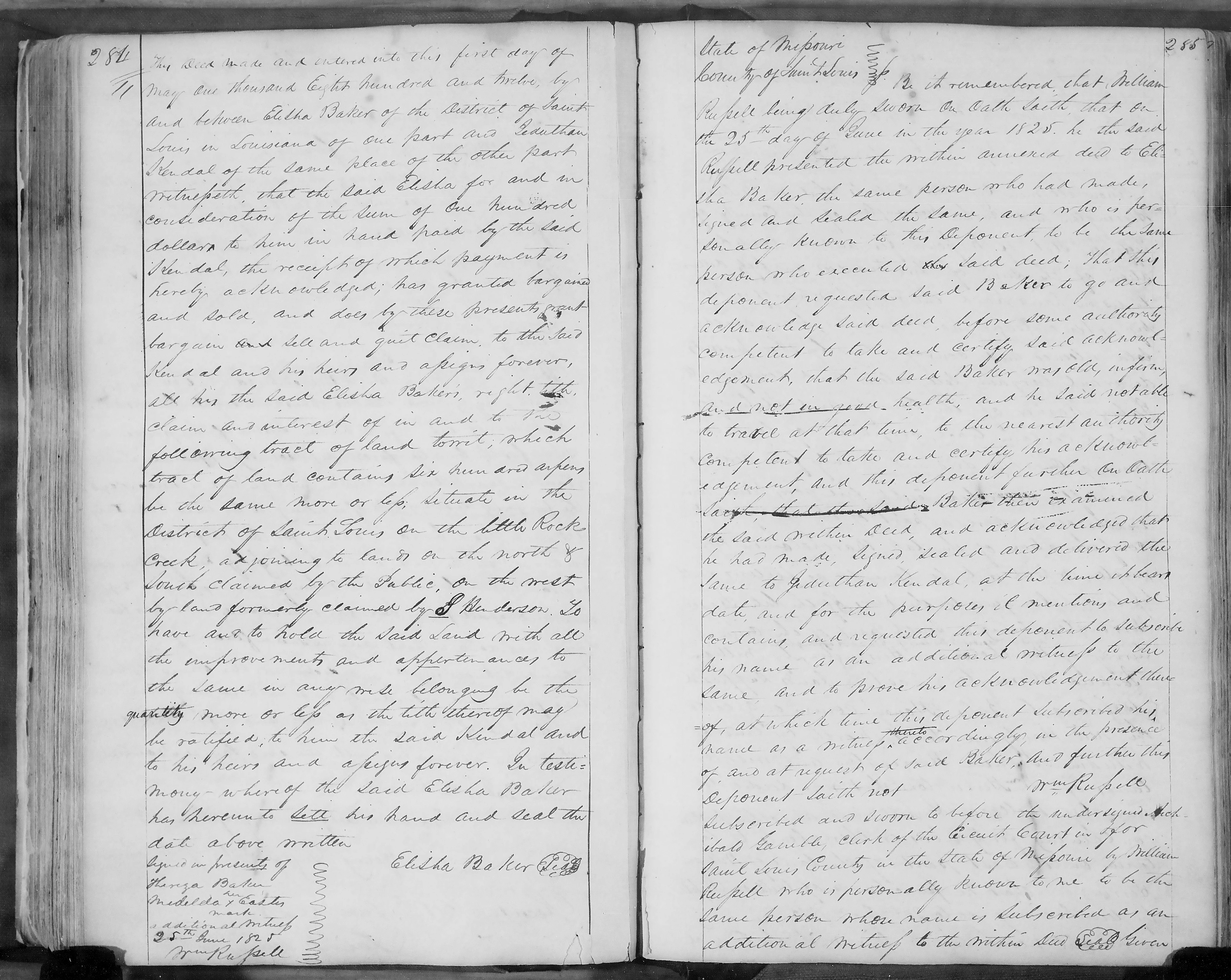
Part Two — after Baker's sale
1812 – 1863
With the claim now in Kendall's hands, it passes through an unresolved administrative backlog. A rejected-claims compilation lists "Jeduthan Kendall, assee. of Elisha Baker, 640 acres, Little Rock." Separately, Recorder of Land Titles Frederick Bates, in a supplementary report dated 16 July 1818, describes a batch of similarly situated claims as "regularly entered and recorded" but never formally classed.
Rejected-claims compilation, "Public Records 1815–1824, Claims in Louisiana and Missouri"; Frederick Bates supplementary report, 16 July 1818.Congress confirms 640 acres of the claim to "Elisha Baker's representatives" — by this point in the process, best read as Kendall, holding by assignment, rather than as evidence of Baker's death; Baker himself would go on to personally sell the Bellevue tract, with full warranty, later this same year.
Notice of claim, William Ruppell, agent; confirmation record citing the Act of Congress of 29 April 1816; American State Papers, Public Lands, Vol. III, p. 307 (640 acres granted).Jeduthan Kendall and his wife Margaret quitclaim 213 acres of the confirmed tract to Benjamin Johnston, Jr., for $200. Austin Byrd, an adjoining landowner, signs as a witness.
Jeduthan Kendall & Margaret Kendall to Benjamin Johnston Jr., quitclaim deed, 7 August 1820, Jefferson County.Austin Byrd, who by this point holds a portion of the tract, dies. His estate, administered by John Byrd and later referenced as administered by Austin M. Johnston, includes Little Rock Creek land. A probate petition for sale of real estate is filed at Hillsboro to raise funds for the estate's debts.
Estate of Austin Byrd, deceased — petition for sale of real estate, Jefferson County Court, Hillsboro.Eliza Horne and others sue John Byrd, Jacob Byrd, and other Byrd heirs in Jefferson County Circuit Court, seeking to divest Austin M. Johnston and Benjamin Johnston of title acquired through the estate administration and vest it in Austin Byrd's rightful heirs — covering 101 and 106 acres on Little Rock Creek. A later motion to dismiss an appeal indicates the case proceeded beyond the circuit court.
Eliza Horne et al. v. John Byrd, Jacob Byrd, et al., Jefferson County Circuit Court, notice dated Thursday, 5 December 1850.Benjamin Johnston sells 151 acres of Survey No. 2021 to George Engelman for $1,800, land Johnston had acquired via the Byrd estate administrator.
Benjamin Johnston to George Engelman, deed, 1 May 1854, Jefferson County.Deputy surveyor Isaac S. Baker retraces Survey No. 2021, confirming its location in Township 42 North, Ranges 5 & 6 East of the 5th Principal Meridian, just west of Hillsboro.
Surveyor General's certificate of retracement, Survey No. 2021, January 1863.